No edit summary |
No edit summary |
||
| (17 intermediate revisions by the same user not shown) | |||
| Line 3: | Line 3: | ||
|country=France | |country=France | ||
|city=Paris | |city=Paris | ||
|neighbourhood=Évry-Courcouronnes | |||
|begin-date=2025-12-01 | |||
|end-date=2026-10-31 | |||
|participating-organizations=Municipality of Évry-Courcouronnes; Région Île-de-France; Pony; Île-de-France Mobilités; Conseil Départemental de l'Essonne; Agglomération du Grand Paris Sud; Université Gustave Eiffel; Institut Paris Région | |||
|location=48.62586, 2.40995 | |location=48.62586, 2.40995 | ||
| | |description=The Paris Living Lab is situated in Évry-Courcouronnes, a suburban new town where peripheral business sectors remain highly car-dependent. To address severe first- and last-mile connectivity gaps to the Tram 12 corridor, the lab tested the deployment of strategic shared mobility stations, discounted shared mobility subscriptions for students, and the creation of a new protected bi-directional bike lane. | ||
|focus=Évry-Courcouronnes has a landscape shaped by high-density housing alongside dispersed, highly car-dependent economic activity areas. While the city is connected to regional transit (T12, RER D, and bus networks), daily commuters often face last-mile accessibility gaps to their workplaces and fragmented cycling infrastructure. Additionally, the city has strong social contrasts and a large student population (nearly 10% of residents) for whom the cost of shared mobility services presents a barrier. Focusing on these specific spatial and economic disparities made it the right environment to pursue targeted interventions aimed at fostering a more inclusive and continuous multimodal mobility network. | |||
| | |approach=The primary aim was to improve multimodality and 15-minute accessibility within the T12 corridor by bridging last-mile gaps and reducing car dependency. This implies increasing the uptake of active and shared modes, improving perceived safety for cyclists, and successfully integrating shared mobility with existing public transport networks. | ||
| | |||
| | To achieve this, we try to analyse the effects of physical infrastructure, service deployments and economic incentives to create strong synergies. The interventions included the implementation of virtual shared mobility stations to reduce the average distance between stations, introducing a discounted €30 monthly pass for students to lower economic barriers, and constructing 500 meters of protected bi-directional bike lanes to guarantee a safer, continuous route connecting peripheral neighbourhoods to transit hubs. | ||
| | |interventions=#'''New shared mobility stations''': Adding 3 virtual shared mobility stations in the economic activity areas of Saint-Guénault & Bois de l’Épine.<br>''Partners:'' Pony, Municipality of Évry-Courcouronnes | ||
#'''New bi-directional bike lane''': Constructing 500 metres of protected cycling infrastructure on the Avenue des Champs-Élysées to connect with the T12 cycle path.<br>''Partners:'' Municipality of Évry-Courcouronnes | |||
#'''Discounts on shared mobility solutions''': Offering a €30 discounted monthly subscription plan with unlimited usage for users holding a valid student card. <br>''Partners:'' Pony | |||
|what-happened=The implementation process required significant adaptation and flexibility. Initially, the lab intended to include the municipality of Massy and focus broadly on mobility hubs; however, the withdrawal of the shared bike operator "Fifteen" forced the project to drop Massy and refocus exclusively on Évry-Courcouronnes, where the operator "Pony" remained active. The ambitious goal of creating full mobility hubs was also abandoned due to the complex institutional and regulatory environment. | |||
Once refocused, the lab faced considerable institutional resistance regarding public space allocation in some areas. Municipal authorities declined requests to convert car parking spaces into shared mobility stations, which severely constrained deployment options in the targeted car-dependent zones. Furthermore, political cycles and municipal elections disrupted momentum, as decision-making processes became less reactive and slowed down the validation of interventions. | |||
Engaging with target audiences yielded mixed results. While engaging with students at the university campuses was successful and straightforward, reaching commuting employees in the business parks proved extremely difficult. Communication channels within these business parks were fragmented, limiting direct contact with local companies and workers. | |||
Despite these hurdles, the municipality acted as a strong driving force behind the development of the new protected bi-directional bike lane, successfully adding 500 metres to the network in December 2025. | |||
On the other side, Pony implemented the new virtual stations in the Saint-Guénault and Bois de l’Épine activity parks very quickly after city approval. However, the stations stayed underused, mainly because vehicles were not dispatched there on a regular basis. The absence of physical ground markings also proved ineffective, as the completely virtual nature of the stations severely hindered visibility and the recruitment of new users. | |||
|learnings=The single most important lesson is to maintain extreme flexibility as Living Labs are highly vulnerable to shifting political cycles, the sudden withdrawal of private mobility operators and the low responsiveness of partners and city representatives as their availability can fluctuate drastically when they are focused on larger strategic projects or tenders. | |||
While implementing virtual shared mobility stations is technically simple, overcoming municipal resistance to reallocating public space is a major hurdle. In car-dependent areas, expect requests to replace car parking spots to be systematically declined, requiring replanning for alternative locations early on. Furthermore, our experience showed that fully virtual stations severely hinder user adoption in low-density, car-oriented areas; physical ground markings are a crucial minimum requirement to make the service visible and attract users. | |||
Finally, reaching commuting employees in peripheral economic zones is very difficult due to fragmented communication channels among local businesses. To overcome this, proactively secure the city’s commitment to support your outreach (such as leveraging municipal social media channels and coordinating with higher agglomeration authorities) to effectively reach companies within targeted business parks. | |||
|headline-image=ParisBikelane.png | |||
|headline-image-caption=New bi-directional bike lane | |||
|images=ParisScooterStation.png; | |||
ParisScooterHub.png; | |||
ParisLL.png/Cover for the Paris LL | |||
|quote="I can’t believe an international research project chose to work in Évry-Courcouronnes alongside major European capitals. We certainly have a lot of accessibility issues here, but to me, the 15-minute city always felt like a concept for large urban centres, not for peripheral towns like ours." | |||
|quote-attribution=A civil society participant – during the Backcasting workshop in Évry-Courcouronnes | |||
|related-steps=[[Build and jointly assess scenarios|SUMP Step 4: Build and jointly assess scenarios]]<br>[[Agree actions and responsibilities|SUMP Step 8: Agree actions and responsibilities]] | |||
|accessibility-tool=https://minutemapper-evry-courcouronnes.up.railway.app/ | |||
|survey-results=https://dreams.mobyome.at/index.php?title=Special:Radarchart&file=File:ResimobSurvey-Paris.csv | |||
}} | }} | ||
Latest revision as of 12:47, 5 October 2026
Évry-Courcouronnes has a landscape shaped by high-density housing alongside dispersed, highly car-dependent economic activity areas. While the city is connected to regional transit (T12, RER D, and bus networks), daily commuters often face last-mile accessibility gaps to their workplaces and fragmented cycling infrastructure. Additionally, the city has strong social contrasts and a large student population (nearly 10% of residents) for whom the cost of shared mobility services presents a barrier. Focusing on these specific spatial and economic disparities made it the right environment to pursue targeted interventions aimed at fostering a more inclusive and continuous multimodal mobility network.
The primary aim was to improve multimodality and 15-minute accessibility within the T12 corridor by bridging last-mile gaps and reducing car dependency. This implies increasing the uptake of active and shared modes, improving perceived safety for cyclists, and successfully integrating shared mobility with existing public transport networks.
To achieve this, we try to analyse the effects of physical infrastructure, service deployments and economic incentives to create strong synergies. The interventions included the implementation of virtual shared mobility stations to reduce the average distance between stations, introducing a discounted €30 monthly pass for students to lower economic barriers, and constructing 500 meters of protected bi-directional bike lanes to guarantee a safer, continuous route connecting peripheral neighbourhoods to transit hubs.
- New shared mobility stations: Adding 3 virtual shared mobility stations in the economic activity areas of Saint-Guénault & Bois de l’Épine.
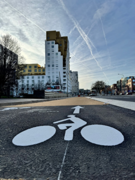
Partners: Pony, Municipality of Évry-Courcouronnes - New bi-directional bike lane: Constructing 500 metres of protected cycling infrastructure on the Avenue des Champs-Élysées to connect with the T12 cycle path.
Partners: Municipality of Évry-Courcouronnes - Discounts on shared mobility solutions: Offering a €30 discounted monthly subscription plan with unlimited usage for users holding a valid student card.
Partners: Pony
The implementation process required significant adaptation and flexibility. Initially, the lab intended to include the municipality of Massy and focus broadly on mobility hubs; however, the withdrawal of the shared bike operator "Fifteen" forced the project to drop Massy and refocus exclusively on Évry-Courcouronnes, where the operator "Pony" remained active. The ambitious goal of creating full mobility hubs was also abandoned due to the complex institutional and regulatory environment.
Once refocused, the lab faced considerable institutional resistance regarding public space allocation in some areas. Municipal authorities declined requests to convert car parking spaces into shared mobility stations, which severely constrained deployment options in the targeted car-dependent zones. Furthermore, political cycles and municipal elections disrupted momentum, as decision-making processes became less reactive and slowed down the validation of interventions.
Engaging with target audiences yielded mixed results. While engaging with students at the university campuses was successful and straightforward, reaching commuting employees in the business parks proved extremely difficult. Communication channels within these business parks were fragmented, limiting direct contact with local companies and workers.
Despite these hurdles, the municipality acted as a strong driving force behind the development of the new protected bi-directional bike lane, successfully adding 500 metres to the network in December 2025.
On the other side, Pony implemented the new virtual stations in the Saint-Guénault and Bois de l’Épine activity parks very quickly after city approval. However, the stations stayed underused, mainly because vehicles were not dispatched there on a regular basis. The absence of physical ground markings also proved ineffective, as the completely virtual nature of the stations severely hindered visibility and the recruitment of new users.
The single most important lesson is to maintain extreme flexibility as Living Labs are highly vulnerable to shifting political cycles, the sudden withdrawal of private mobility operators and the low responsiveness of partners and city representatives as their availability can fluctuate drastically when they are focused on larger strategic projects or tenders.
While implementing virtual shared mobility stations is technically simple, overcoming municipal resistance to reallocating public space is a major hurdle. In car-dependent areas, expect requests to replace car parking spots to be systematically declined, requiring replanning for alternative locations early on. Furthermore, our experience showed that fully virtual stations severely hinder user adoption in low-density, car-oriented areas; physical ground markings are a crucial minimum requirement to make the service visible and attract users.
Finally, reaching commuting employees in peripheral economic zones is very difficult due to fragmented communication channels among local businesses. To overcome this, proactively secure the city’s commitment to support your outreach (such as leveraging municipal social media channels and coordinating with higher agglomeration authorities) to effectively reach companies within targeted business parks.


